Turgay plateau - Turgay Discovery
Main menu
- Main page
- News
- Project Keepers Geoglyphs Turgay
-
Our expeditions
- Expedition 2007
- Expedition 2008
- Expedition 2009
- Expedition 2014
- Expedition 2015
- Expedition 2016
-
Working materials
- Presentation Turgay Discovery
- Working hypothesis
- Base on these geoglyphs
- Library
- Scientific section
- Interview
- Multimedia content
- Internet-resources about Turgay
- Contacts
Turgay plateau
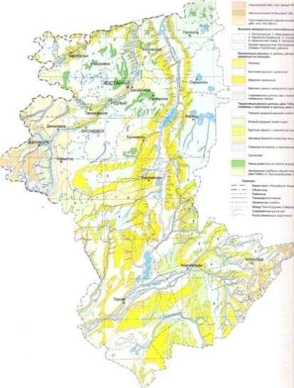
The Turgai plateau settles between the southern Ural Mountains and the Mugodzhars in the west, and the Kazakh melkosopochnik with raisings of the Kokchetav and Ulutau Mountains in the east. Unlike the territories to be mentioned next where folded Paleozoic structures surface, the Turgai plateau represents an epigerzinsk platform formation with rather deep burial of the Paleozoic base. Tectonically, it has a complicated correspondence with breaks of the Turgai syneklize, connecting along the Western-
The Turgai hollow is on a lowered narrow strip extending to the south in the middle of the described territory, almost in meridian direction. Absolute heights here are 100-
To the west and the east of the Turgai hollow the height increases to 200 meters, sometimes to 300 meters. The surface is combined by horizontal layers of paleogene and neogine adjournment. Paleogene (oligocene) is represented mainly by the solenoid clay and alluvial lake precipitation, and the neogene (miocene) mainly by continental sands.
The northern part of the Turgai plateau was poorly dismembered, where low hills and lake hollows are characteristic. To the south of the plateau, dismemberment was ordered by a system of hollows on the isolated table heights. Some that are lowered had transformed into flat remains, which tower over flat-
The remains at the Stolovo-
Physiography of USSR: http://www.ecosystema.ru/08nature/world/geoussr/1_2.html
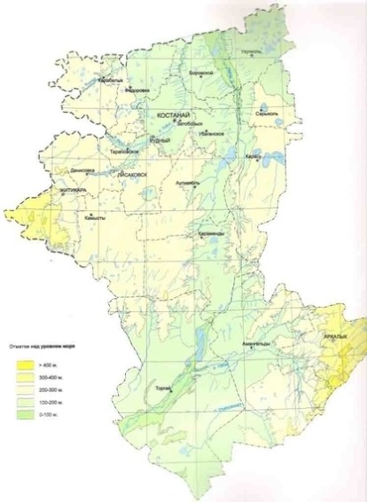
Hypsometric map of Kostanai oblast
The Turgai hollow can easily be viewed on both maps.
Geomorphological map of Kostanai oblast