Expedition 2008 - Turgay Discovery
Main menu
- Main page
- News
- Project Keepers Geoglyphs Turgay
-
Our expeditions
- Expedition 2007
- Expedition 2008
- Expedition 2009
- Expedition 2014
- Expedition 2015
- Expedition 2016
-
Working materials
- Presentation Turgay Discovery
- Working hypothesis
- Base on these geoglyphs
- Library
- Scientific section
- Interview
- Multimedia content
- Internet-resources about Turgay
- Contacts
Expedition 2008
One of the tasks of Expedition 2008 was to research the Ushtogai square with the help of gauges to detect any artifacts, which might shed light on its mysterious construction. The most optimal variant would be to scan the ground by geo-
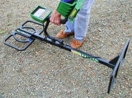
We acquired a Garrett GTI 2500 (PRO) metal detector with a TreasureHound Eagle Eye depth magnifier. Using a standard coil to search for metal objects up to 25-
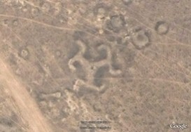
The expedition investigated the of object "Turgai swastika". The construction discerned from the height of a bird's flight was hardly visible. Having the height of 20m2 and being too sagged, the object was of clear-
An analogous object of a three-
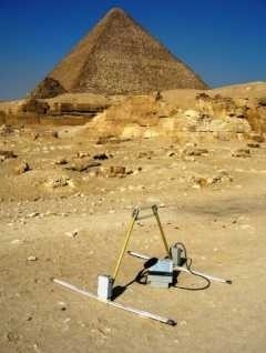
Expedition 2008 defined the necessity to use geo-
Fortunately, in November 2008, geologists from Kostanai city bought the geo-
At present times thanks to new methods of decoding, high-
The opportunities of the survey were great, because from the surface of the ground many objects could be brought to light and revealed. These objects were invisible before digging, and the survey allowed people to recognize its structure, depth of deposit and capacity.
Some new objects were discovered during the course of exploration with the help of Google Earth satellite pictures. Four constructions in the shape of a cross consisted of several burrow-
The length of the big cross was approximately 460 meters. One of the objects was constructed in the form of 25 burrow-
Many remains of irrigational constructions were found along the rivers of the Turgai region. Nikolai Petrovich Rychkov (1746-